The
John Muir Trail
The 211 mile long John Muir Trail 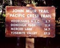 is one of the best known and loved trails in the United
States. It
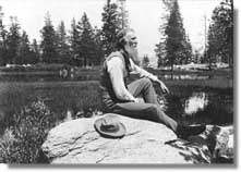
gets its name from the prominent naturalist, environmentalist
and founder of the Sierra Club.
The serene beauty and solitude one encounters while
hiking the Muir Trail keeps backpacking enthusiasts
from all over the world coming back year after year.
is one of the best known and loved trails in the United
States. It
gets its name from the prominent naturalist, environmentalist
and founder of the Sierra Club.
The serene beauty and solitude one encounters while
hiking the Muir Trail keeps backpacking enthusiasts
from all over the world coming back year after year.
The trail spans many of California's National Forest
and National Park lands as well as a National Monument.
These include: Yosemite,
Kings Canyon and Sequoia National Parks, Inyo National
Forest (including the John Muir and Ansel Adams Wilderness
areas), and Devils Postpile National Monument.
There are quite a few places where one can pick up the
trailhead for the Muir Trail. On the south end you can
start 3
hours north of Los Angeles on
Hwy 395,
west of Lone Pine. From the north, the trailhead can
be found in Yosemite Valley using Hwys 120 or 140 from
the west. From the east side of the Sierras use Hwy
395 at Lee Vining by way of Hwy 120 over Tioga Pass.
A nice place to pick up the trail near the mid-way
point is at Florence
Lake in the John Muir Wilderness Area
near the north end of Kings Canyon National Park. This
is also a great place to resupply and/or to send or
recieve mail at the Muir
Trail Ranch. The Vermilion
Valley Resort at Edison Lake is also
an option for resupply.
Wilderness
permits are required for all overnight
stays and even for day trips throughout the Mt. Whitney
area. A small fee is charged for mail away permits,
but for those who aquire them in person the fee is waved.
See our section on Wilderness
Permits for more information.
For
guide books and maps of the John Muir Trail and other
backpacking destinations in the High Sierra, please
refer to our High
Sierra Library. You may also want to
take a look at the High
Sierra Topix message board to read what
others have said about the area and to posts questions
or information of your own.
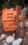 The
John Muir Wilderness Area
The
John Muir Wilderness Area
The John Muir Wilderness Area also gets its name from
the prominent naturalist, environmentalist and founder
of the Sierra Club. The
581,000+ acre wilderness area is the largest and most
visited wilderness in California. It extends over 100
miles along the crest of the Central Sierra Nevada and
encompasses both the Sierra National Forest and Inyo
National Forest. It is characterized by splendid central
California mountain wild land: high peaks, deep canyons,
extensive and beautiful meadows, hundreds of bright
streams and crystalline lakes. The South and Middle
Forks of the San Joaquin River and the North Fork of
the Kings River originate in this region.
 "Thousands
of tired, nerve-shaken, over-civilized people are
beginning to find out that going to the mountains
is going home; that wilderness is a necessity; and
that mountain parks and reservations are useful
not only as fountains of timber and irrigating rivers,
but as fountains of life"
- John Muir
"Thousands
of tired, nerve-shaken, over-civilized people are
beginning to find out that going to the mountains
is going home; that wilderness is a necessity; and
that mountain parks and reservations are useful
not only as fountains of timber and irrigating rivers,
but as fountains of life"
- John Muir